Menu
Menu
Hetao Irrigation District
Profile; ?>Situated in Bayannur city, Inner Mongolia Autonomous Region, the Hetao Irrigation District covers one of the most significant ancient irrigation areas in the Yellow River basin. Enjoying a temperate continental arid and semi-arid climate zone, average annual precipitation and average annual evaporation in the area are 169.4 mm and 1500 mm respectively. The Hetao Plain is a flat and fertile region, enabling the irrigation of the Yellow River to support the agricultural and economic development of the region. The system is, therefore, a witness of the conflicts and combinations between nomadic civilization and farming civilization in the long history.
History
Irrigation activities in the Hetao region date back to Qin dynasty and had been recorded and documented since the Han dynasty. In 215 B.C., Meng Tian, a famous general in Qin dynasty, conquered areas south to the Yellow River, including Hetao Plain, and led people to settle down and farm there, thus starting the history of agricultural development in the place. In Han dynasty, there have been explicit writings of irrigations introducing the Yellow River in Hetao area in many documents, including Records of the Grand Historians. Other evidence telling the time of scale irrigation includes a seal with official inscriptions, excavated as a seal for the administration of agriculture and irrigation in Hetao during the rule of Emperor Wu of Han. The development of cultivation and irrigation continued in the Northern and Southern dynasties when the main canal of the project was called the branch canal. However, the rapid development of farming in the plain had not come until the unification of China in the Sui and Tang dynasty. According to records of that time, there were three canals, namely Lingyang, Xianying and Yongqing, during Tang dynasty, and the total irrigation area covered 480,000 mu, and annual grain production reached 400,000 hu. The landmark Shuibushi, or Water Administration Regulations, released by Tang government, standardized the construction of irrigation structures and management at the national level, promoting further development of irrigation farming.
During the period from late Tang dynasty to the middle stage of Qing dynasty, the irrigation area had long been treated as grazing land where the development of the agricultural economy was limited and large-scale construction of Yellow River irrigation was stalled. This situation lasted until the end of the 18th century, as the dramatically growing population led to a large number of people moving into the Hetao Plain. People in the place began to voluntarily initiate the construction of irrigation structures and introduce the River as the water supply for farms, which could be represented by Yangjiahe River and Chanjinqu Canal built during the rule of Emperor Qianlong and Emperor Jaiqing. After that, Emperor Daoguang lifted bans on cultivations in the Hetao grazing area, accelerating the construction of irrigation structures diverting water from the Yellow River. In 1850, the Hetao section of the Yellow River was rechanneled from Wula River in the north to the route in the south (the mainstream nowadays). The channel the served as the new water supply of the system of Hetao Plain irrigation structures, and the water system of the original estuaries was also reestablished into canals for the structure. The driving force for constructing irrigation structures later became businessmen. In 1911, there had been over 40 canals diverting the water of the Yellow River, consisting a system with eight major canals, namely Yongji, Gangji Gengji, Shahe, Yihe, Tongji, Changji and Tabu river. The system irrigated over 66,667 ha in the area, and the Hetao Irrigation District began to take shape.
The whole Hetao Irrigation District was formed hence, supplying water for an area of more than 4 million mu. After 1949, the system and the corresponding administrative regulations developed rapidly. The Sanshenggong diverting system, established in 1961, marked that the irrigation system entered a new era featuring the ever-updating water supply and drainage systems and the integration of main structures and seven supporting systems for irrigation and drainage.
The Structure and Heritage of the System
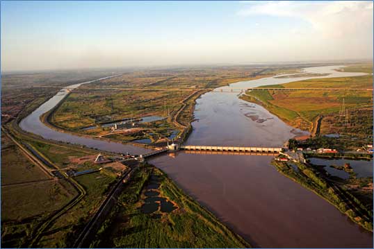
The water of the Yellow River starts its journey across the Hetao Irrigation District at Sanshenggong headwork, and flows through the main canal, 13 branches and supporting channels to supply water for farms and lakes. Then, the water will enter the drainage receiver in the Wuliangsu Sea through the Honggebu pumping station and return into the Yellow River at the exit section of the main drainage system, completing an irrigation system with one single water intake. The system consists of 183,500 structures in total and covers more than 9 million mu in the area. The heritage of Hetao Irrigation District includes the 8 major ancient canals, the original system before 1949, remains and historical sites of the abandoned structures, and those non-engineering items of historical and cultural values, including inscriptions, documents, water-deities worship temples and management facilities.
Administration
Different administration applied to Hetao Irrigation District in different historical stages. The management during the period from Qin dynasty to Tang dynasty was a mode with the government as the main body against the background of the farming system. The administration since Qing dynasty to the Republic period was mainly in charge of non-governmental organizations or individuals, while the mechanism where governments oversaw the constructions developed. After the establishment of the People’s Republic of China in 1949, the governments weighed in as a dominating force to lead the construction and management of the irrigation system, and the benefiting rural households were in charge of the specific management in fields. The guarantee for the sustainable development of the irrigation area is that the management system is specific in duties and obligations, efficient and appropriate and corresponds with time.
Benefits
Since the establishment, Hetao Irrigation District has been promoting agricultural production, improving the ecological environment, keeping social stability and securing sustainable development. The benefits of Hetao Irrigation Structure can be summarized into the following categories:
Irrigation benefits
Statistics of irrigation coverage, food output and population have reflected the profound impact of the irrigation structure on social and economic development on the Hetao Plain. Throughout the 2,200 years of Hetao Irrigation District’s history, the irrigated area continued to grow. Though not recorded before Tang dynasty, the number during the 7th to the 8th century is nearly 480,000 mu, 1 million in the early stage of the 20th century, 4 million in the middle age of the 20th century and 9 million at present. The water availability also improved. With effective and efficient irrigation, as grain output and population on the Hetao Plain kept growing. Grain produced during the 7th and 8th century was 25,000 tons, 150,000 tons in the middle age of the 20th century, and over 3 million at present. The number of people in the area grew from 50,000 in Han dynasty (2nd century B.C.) to 400,000 in 1946, and 1 million in 1985. Crops of the irrigation area are mainly wheat, corn, soybeans and sorghum. Other than grain, Lycium barbarum and grape are also featured plants in the area. While Hetao Plain is now a major grain base in northern China, it is the construction and development of the Irrigation Structure that facilitates the prosperity of agriculture and economy of the place.
Political and social benefits
The Hetao Plain has long been an interlaced place for both the nomadic civilization and agricultural civilization. Different ethnic groups and civilizations meet and co-exist here, making the plain a strategic point with not only military but also geopolitical significance. During the period from Qin to Tang dynasty, troops stationed here cultivated and safeguarded the place, making the plain a strategic region for governments to stabilize the political and economic situation in northern China and unite ethnic groups. In Ming and Qing dynasty, non-governmental forces furthered the construction of local irrigation structures and played a critical role in stabilizing regional economy and society.
Ecological benefits
Hetao Plain is located in the middle and upper reaches of the Yellow River and the arid and semi-arid climate zone, where the annual precipitation is 169.4mm and annual evaporation is 2194.5mm, meaning the water evaporated is 10-16 times the average rainfall. The construction and development of the Hetao Irrigation District greatly facilitated the transition from nomadic civilization to agricultural civilization. As a result, such a transition enabled local people to take various measures in improving agricultural ecology based on the dramatically increased capacity for the place’s population and economy. The Hetao Irrigation Structure mainly realizes irrigation and diversion without dams, which caused little influence on the environment, and managed to exist for over 2,000 years without rendering detriments. In addition, the professional planning of warping irrigation and crop rotation increased the fertility of the saline-alkali land. The irrigation system across the whole Hetao Plain realized the relatively even distribution of local water resources and generally improved the ecological conditions of the place. In conclusion, as a heritage irrigation structure, the Hetao Irrigation Structure greatly benefited the local environment and is an exemplar characterized with agricultural science in the arid zone and sustainable development.
Water Heritage
The Hetao Irrigation District represents a milestone / turning points in development of irrigated agriculture and bears an exceptional testimony to development of agriculture and increase in food production along with the improvement of the economic condition of farmers;
The establishment and development of the structure that diverted the Yellow River in the Qin dynasty and Han dynasty is the preclude for the agricultural development in Hetao Plain. The construction of the supporting structures at the end of Qing dynasty was a turning point and milestone ushering in an era when modern agriculture in the Hetao region embraced rapid development. In conclusion, the constructions of the irrigation system laid the foundation for Hetao Irrigation District to become a major grain-producing base.
The Hetao Irrigation District was ahead of its times in terms of project formulation, engineering design, construction techniques, dimensions of the structure itself, quantum of water diverted, and size of the command;
The Hetao Irrigation District is a classical large-scale irrigation project in Mongolian Plateau in China. The coverage of the system reached over 480,000 mu in Tang dynasty and 100 in Qing dynasty. In 1940, the area irrigated was more than 4 million mu and the present coverage increased to more than 9 million mu. Therefore, the irrigation area in the system had always been a representative exemplar where techniques were ahead of its time.
The Hetao Irrigation District made outstanding contribution to enhancing food production, livelihood opportunities, rural prosperity, and poverty alleviation in a region;
The development of the Hetao Irrigation District served as strong support for the nomadic civilization to transform into agricultural civilization, which dramatically increased enhanced food production, increased agricultural output and local capacity for supporting population, and improved economic benefits.
The Hetao Irrigation District contributed to the evolution of efficient and contemporary engineering theories and practices;
A large amount of mud and sand discharged into the river makes the Yellow River the most sediment-laden river in the world, which determined that the irrigation structure was constructed without large barrages or dams. Such a system with relevant small influence upon the environment provided historical references for the construction theories and the evolution of technologies for modern hydropower engineering, hence is of great academic value. The gradient of the irrigation area is small, resulting in poor drainage conditions and severe salinization problems. Referring to practices in the long history, local people summarized systematic methods and measures for crop screening, colmatage, drainage and cultivation practices, thus supporting modern theories and technologies for combatting salinization.
The Hetao Irrigation District is an example of attention to environmental aspects in its design and construction;
The Hetao Irrigation District was constructed with diversion headwork without dam and technologies for salinization prevention, so the whole system was flexible enough to accommodate after the rechannelling of the Yellow River. The ecology and environment were better preserved and guaranteed the essential condition for the irrigation system to develop, so the system is an exemplar of structures of its type in the arid and semi-arid region.
The Hetao Irrigation District was unique in some positive and constructive way
During the evolution of Hetao Irrigation District, engineers chose to apply the small-influence development mode that utilized the high-sediment river to irrigate salinized land and headwork with the dam. The management system corresponds to the social and economic context and is characterized by geographical advantages.
The Hetao Irrigation District bears the stamp of a cultural tradition or a civilization of past;
The Hetao Irrigation District is where nomadic civilization and agricultural civilization meet, so it bears the records of civilizational conflicts and combinations and the political, economic and cultural evolutions. The development of the irrigation area is closely linked to China’s political situation, geopolitical landscape and the changes in population, society and economy. Therefore, the Hetao Irrigation District witnessed the glorious development of the Chinese civilizations and bore the traces of history.
The Hetao Irrigation District is an example of sustainable operation & management
The history of the Hetao Irrigation District is quite long. Through 2200 years, the operation and management system has been changing and developing with the changes of natural, social, economic, political and even military situations, which is especially true since the end of Qing dynasty. In addition, the modest degree of development and the ecology-friendly planning enabled the area to enjoy sustainable development and thus become an exemplar of sustainable irrigation.
Present State of Conservation
The Hetao Irrigation District has experienced ups and downs throughout the 2,200 years, during which the river system, layout of canals and channels, and irrigation area had been changing. Many od ancient or early-stage structures and facilities had vanished in the process. At present, the irrigation structure is preserved the same with that in the late stage of Qing dynasty. The Sanshenggong irrigation structure built in 1961 integrated the existent scraps of channels and canals, and unified diversion headworks. The irrigation and drainage system also improved and thus increased irrigation coverage and water availability. The preservation of today’s irrigation area is mainly protecting the structures, as the Administration of Hetao Irrigation District is in charge of the work, maintains the facilities and builds Museum of the Yellow River Irrigation Culture to preserve cultural items and heritages of the irrigation structure. At present, authorities in the irrigation area are formulating plans to protect and preserve the heritage structure. Once completed, the plans will serve as legal documents to systematically manage and preserve the structure and guarantee sustainable development.
HIGHLIGHTS
Country: China
Province: Bayannur
Latitude : 40.52744298582661 Longitude : 106.64720467481976
Built: 2nd Century B.C.
River: Yellow River Basin
Irrigated Area: 67000 Ha
70th IEC Meeting, Bali, Indonesia, 2019