Menu
Menu
Abbas Abad Complex
Profile; ?>The historical complex of Abbas Abad is located 9 km South-East of Behshar next to AliTappeh (Al- Tappeh) village within a dense forest of Alborz highlands. There are numerous springs in southern, south-western and south-eastern highlands of the forest region of Abbas Abad. Two of these springs are of more importance namely: Sarcheshmeh and Qari-cheshmeh which are described below:
Sarcheshmeh Spring is located about 3500 m south-west of the historical garden of Behshahr and has a high discharge of water. What is significant about it (which was probably also important in the past) is that at present it supplies the reservoir of Abbas Abad dam with water in winter.
Qari or Quri Cheshmeh: Since water comes out of this spring in a bubbling fashion, it is known as Qari or Quri Cheshmeh which in Farsi is the noise made this way. The spring is located at a distance of about two km south-east of Abbas Abad complex and has less discharge than Sarcheshmeh spring but more than similar springs inside Abbas Abad. It serves as the only source of supplying water to Saro village north of Abbas Abad complex which has also been verified by valid documents.
Architectural Features – Abbas Abad Dam
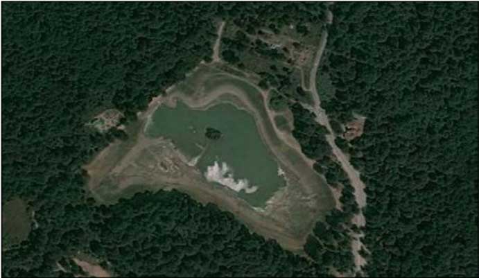
Abbas Abad dam of Behshahr was constructed in a deep valley. After the construction of its foundation, two arms were added to either side of its foundation which not only increased the foundation strength but also enhanced the water intake of its reservoir. On the whole, the arm length of the dam was 70m and its width at its crown was 7m. Behind the dam wall, a backstay was built which in addition to strengthening the dam against the potential energy of water, also served as the control centre of dam water discharge. Other characteristics of Abbas Abad dam are as follows:
Foundation Dimensions: width - 20 m; length - 10 m; height - 10 m
Total water intake capacity: 600,000 m3
Lake area: 98,000 m2
Maximum depth: 10 meters
Building materials: brick-stone and plaster of lime and ashes or sand (Saroodj)
Dimensions of bricks used in the dam: 26 by 26 by 5 cm.
Reservoir water is discharged via dam valves for agricultural purposes of villages located to its north such as Shah-kileh, Al-Tappeh and Saro.
The combinational Chahar Taqi inside the pool: In the middle of Abbas Abad dam reservoir, there is a brick structure in the form of a Chahar Taqi. The above mentioned Chahar Taqi goes underwater during the water intake of the dam and only its upper surface remains out of the water like an island.
Towers: Two brick towers have been constructed at a distance of 186m from the garden and 156m apart. Both towers had entrance doors which were obstructed in 1367 solar AH to stop unauthorized entry and damage to the doors.
Project System and Heritage Composition
Before describing the water supplying method, Chahar Bagh compound must be introduced in more detail and its status, significance and role in water distribution for this historical Safavids garden should be discussed. Chahar Bagh compound has an area of about 3200 square meters and is located at a distance of 600 m south-east of the historical garden on the southeastern slope of the mountain overlooking the dam. During Safavids rule, the slope has been scraped and turned into a flat surface with an area of 46 by 72m. Due to the gradient, there is a level difference of 15 meters between the compound and the garden which is the reason why the compound has been chosen as the water distribution point.
Water delivery from Chahar Bagh to the historical garden
In 1380 solar AH, three test boreholes were dug alongside each other at the second phase of Abbas Abad excavations to gain better insight about the entrance route of water into the historical garden. In each borehole, an architectural monument was encountered which was a 120 by 120 cm brick wall. Next, part of a wall was removed and it became obvious that inside the wall a ceramic pipe was inserted with segments connecting each other in a rabbet fashion (Refer to ceramic pipes design). The wall served as a protective shield for these ceramic pipes (Tanbusheh) which were considered as vital veins for the garden. Clearing the wall shield of the pipe at the second phase of excavations revealed interesting facts. The entry and exit paths of water were exactly shown so that one side of the wall protecting the ceramic pipe was connected to Chahar Bagh compound and the other side went into the main basin inside the central platform of the historical garden. This connection primarily indicates that water supply was directed from the Chahar Bagh compound to the main garden.
Water supply method in the historical garden
As mentioned previously, water was delivered by interconnected ceramic pipes to the central basin of the garden in the form of a fountain. Then the excess water which was not supplied in jet form was delivered to side basins located at eastern, western, northern and southern parts by other ceramic pipes connected to the main one (the entry pipe). These pipes went into all four sides of the central platform basin. The eastern basin water was used for irrigating the eastside flower bed opposite the central platform. As the architecture of Abbas Abad is symmetrical, the function of the western basin was like the eastern one with this difference that the western basin in addition to irrigating the western flower bed of the central platform also supplied the water of the Hammam located about sixty meters west of it.
Studying Bagh-e Abbas Abad waterworks during Safavids time shows that aside from enjoying the surrounding jungle scenery, the architectural structure for water direction was also intended to create kind of water melody to soothe the nerves.
Role of Chahar Taghi
As mentioned before, one of the key buildings of Bagh-e Abbas Abad is building pedestals (Chahar Taqi) inside its pool. The upper section of Chahar Taqi is attractive for any visitor because it shows traces of basin, watercourse and fountain. Apart from the recreational function, it also had technical and scientific functions from the dam construction point of view. It was made of eight piers with an approximate perimeter of 4 by 4 meters as well as a central pier.
The central pier had inter-connected network pores. This pier likely served as a valve in emergencies. Consequently, if after closing dam wickets and its full water intake, the dam remained underwater pressure or if it moved a little, there was no need to empty the water via wickets because it was done directly from the reservoir. For example, when water discharge at emergency times took place from wickets, water pressure and surge served as a destroying factor upon the dam.
The same Chahar Taqi with inter-connected meshed pier also prevented the destruction of the dam during emergency times (after water intake). For this reason, civil engineers constructing Abbas Abad dam during Safavids period prevented dam destruction at times of emergency by setting up Chahar Taqi with its meshed pier at the pool centre.
Role of Towers in Water Supply:
According to studies and soundings conducted in the route between Gol-Bagh compound (water distribution station) and the central garden, exactly two brick towers have been built upon the water supplying axis.
When water was cut off suddenly from above (Gol-Bagh compound) the central basin water flowed towards the second tower (due to level difference between the garden and the second tower) and when the Gol-Bagh compound water began to flow again, the stimulant confluence of currents caused a severe clash which is termed ram-like stroke in fluid engineering. Even today, such a strong blow causes the rupture of iron pipes used in urban waterworks. So it is interesting that engineers, artists and architectures living in Safavids times were fully aware of this law in fluid engineering and took measures to prevent it by building these dual brick towers upon the water supply axis. In this way, they succeeded in protecting 600 m of ceramic pipes against ram-like strokes. Also, by building two brick towers, they were able to prevent the rupture and breakage of Tanbusheh pipes as well as to adjust and control the jet water pressure upon the central basin.
As a conclusion, the towers served as safety valves, siphon traps and above all as pressure relief structures. Also, according to fluid engineering definitions, the twin brick towers of the historical Bagh-e Abbas Abad in Behshahr served as safety valves and siphons (due to level difference between Gol-Bagh compound and the garden) for water supplying as well as preventing the sudden cracking or breaking of ceramic pipes.
Present State of Conservation
Probably, the first archaeological researches in Behshahr- Abbas Abad were done on the flung open building in the centre of the Abbas Abad basin in 1977 before Islamic revolution (head of control: Dr. Aliakbar Sarfaraz). Abbas Abad-e Behshahr is the first place in Mazandaran province that archaeological researches were carried out in the Islamic republic era.
The archaeological researches were done in the historical garden of Abbas Abad in the Hammam in the western part of the garden. These researches were taken at this time to prevent the constructions and to show the architecture phenomenon as well as the sensitivity of the case (head of the board of control: Mohammad Jaafar Nikkhah). The archaeological researches were carried out for three reasons, namely:
- To identify the water pipes and watercourses to know how the water enters the garden
- Carrying out archaeological researches on Gol-Bagh to recognize the importance of this part in allocating water of the historical complex
- Determining the core and buffer zones of the garden increased to 530 hectares and excavating archaeological sites such as mill, palace, industrial centres of making brick and crockery, stone pavements of Safavids period and the cemetery (the first millennium B.C), and finally, their map was provided.
The past conservation reports
Based on the archaeological findings in Bagh-e Abbas Abad, we can observe three historical layers in this historical complex. The first is the Safavids period or the beginning of constructions and with the other two following it. For example, we can mention building pavement and obstructing the platform corridors as far as the lower platforms. All these changes will be included in a past repairs report.
The present conservation activities Steering Committee of the base made and passed important decisions about the method of garden conservation. Finally, the conservation actions were performed based on the archaeological findings during 10 years of researches in the historical garden of Abbas Abad in Gol-Bagh and its palace. The base continued to repair architectures discovered during archaeological researches. For example, we can name the garden axes containing passages and open irrigating canals. In this method, the bricks are made in a new frame but their size and their material are original. In general, the eastern road (the main entrance of the garden), the northern road, and some parts of the southern roads have been unearthed completely.
HIGHLIGHTS
Country: Iran
Province: Mazandaran
Latitude : 32.115195160042276 Longitude : 52.871373912675494
Built: 1021 lunar AH (approx. 1612)
River: Neka-Rood
Sub-Basin: Abbas Abad River
Irrigated Area: 75 Ha
70th IEC Meeting, Bali, Indonesia, 2019