Menu
Menu
Jukkoku-bori Irrigation System
Profile; ?>The Jukkoku-bori Irrigation System was constructed in 1669, on a plateau where the farmers had been annually dealing with crop damage from water scarcity and were always poor, based on farmers’ idea and planning.
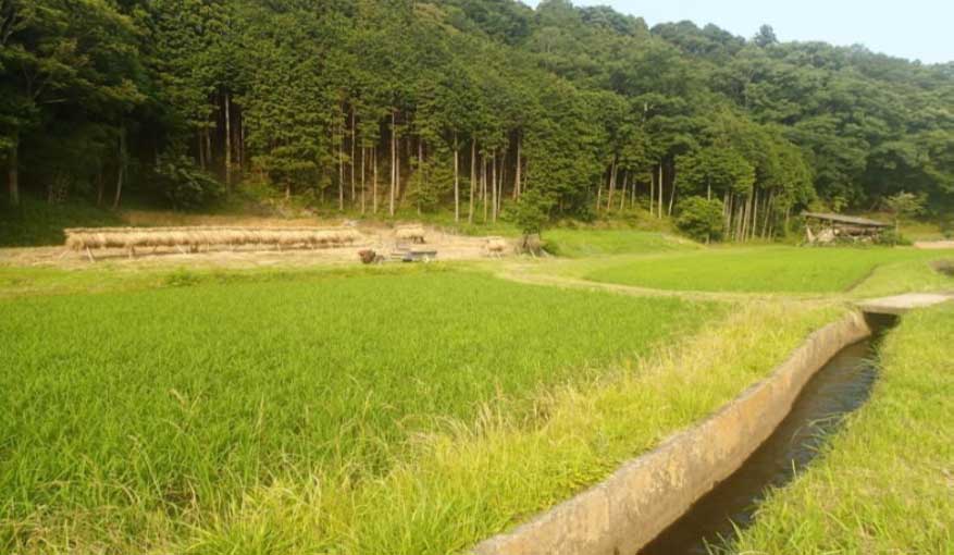
It is composed of an irrigation canal (collectively about 13 km-long), two intake gates and two-division works; and it irrigates 78 ha of paddy fields with the maximum water intake of 0.36 m3/s. Although several portions of the canals have been renovated to concrete lining types, canals of at least 2 km from the upper intake facilities have remained unchanged over the last 350 years.
In 1668, Mr. Kazue Numata, village chief of Matsui involving two nearby villages of Hitana and Awano, made a petition to the lord of the area for constructing irrigation canals aiming to eliminate water scarcity and to develop newly irrigated paddy fields. The farmers found the water sources along the branch streams of the Ookita River in the deep mountainous area in cooperation with each other and made a plan of constructing an irrigation canal of 13 km from the water sources making skilful use of the natural geographical conditions. However, the lord, who was apprehensive of the possibility of overcoming the difficulties of the construction and didn’t acknowledge the implementation of the plan at first, finally allowed Mr. Numata to implement the plan respecting his strong determination by taking a vow of risking his life in case of failure.
Construction work, which required only eight months thanks to the cooperation of the farmers, started in August 1668 and was completed in March 1669, provided irrigated paddy fields in three villages. Moreover, the construction cost was only one-tenth of the initial cost estimated due to continuous effort of the farmers’ participation and their voluntary procurement and preparation of construction materials from their forests.
Irrigation water management of Jukkoku-bori is conducted by the Jukkoku-bori Operation and Maintenance Committee comprised of the farmers from three villages (Matsui, Hitana and Awano) where the irrigation water is directly used. Such operation and maintenance system carried out by farmers themselves was formed as a result of succeeding the system formed at the time of the construction where the farmers carried out a study to find the water sources deep inside the mountains working together and performing each role by themselves. This is an outstanding example of long-run operation and maintenance.
The Jukkoku-bori Operation and Maintenance Committee has decided to maintain Jukkoku-bori even in the future in cooperation with the citizens to share it with future generations. The Jukkoku-bori Irrigation system has contributed to the sustainable development of rural area and agriculture. It is a treasure produced by farmers’ wisdom regarding how to plan and construct important facilities and a sophisticated irrigation system to continuously delivering stable irrigation water for more than 350 years without undertaking any big-scale rehabilitation work.
Water Heritage
The structure made outstanding contribution to enhancing food production, livelihood opportunities, rural prosperity, and poverty alleviation in a region;
The farmers in Matsui Village, who seriously and chronically suffered from water scarcity were constantly poor. However, after the construction of Jukkoku-bori, they achieved food self-sufficiency and their poverty was alleviated due to removal of water scarcity. Realising such poverty alleviation, farmers living nearby tried to replicate the idea and constructed 15 irrigation schemes, using the same technical method. Consequently, a base infrastructure for agricultural production in Kitaibaraki City was formed with a paddy field of 1,050 ha, which achieved wealthy rural development without poverty.
In the hillside village of Hitana, the habitants began to produce typical Gaerome Clay made of weathered granite pounded by waterwheels using the water flow from Jukkoku-bori, and it led to the establishment of the new pottery industry, named Matsuoka-yaki Ceramics that helped farmers increase their income and contributed to the development of Hitana village. As it was well-received in the capital city of Japan, a wealthy regional economy was formed by managing and distributing Matsuoka-yaki.
The structure was innovative in its ideas at the time of its construction;
The farmers who sought the water source in the area paid attention to the nearby mountains which were higher than their paddy fields and cooperated in researching and found two suitable water sources; one in Takino-sawa valley 2 km away from their village and another in Karo-sawa valley 4 km away. The two water sources had a catchment area of 4.5 km2 together, 1.6 km2 and 2.9 km2 respectively. The farmers developed the water resources for the area of 4.5 km2 combining the two catchment areas by constructing a connecting channel, Horiwari in Japanese, between two valleys.
Irrigation water was taken, first, through the Karo-sawa Gate set in Karo-sawa valley, and conveyed via the Horiwari channel to Takino-sawa valley and flowed down along the paths of a natural mountain stream in Takino-sawa valley. The combined irrigation water was taken through the Takinosawa Gate set in Takinosawa valley and conveyed to the plateau through a 2.3 km-long irrigation canal bearing inclination of 1/100.
Water resources development of combining two watersheds by a connecting channel made the increase of water flow volume at the point of Takino-sawa Gate by 180%. It drastically changed the farming system from rain-fed to irrigated system with two irrigation canals stretching to the northern direction and southern direction from the division work constructed on the plateau. Such technology was very innovative at that time.
The structure was an example of engineering marvel or excellence at the time of its construction;
Since the survey technology was primitive and adequate survey equipment was not popular at that time, it was not easy to achieve such canal construction work in the mountainous area which required sophisticated technology.
For the levelling survey where good foresight was not secured, the farmers adopted an effective levelling method of using bullets of a hunting rifle in the following manner;
(1) Set up a board at a target point.
(2) Horizontally fire a bullet from the benchmark point to the board at a target point.
(3) Measure the vertical distance (a) between a bullet mark and the ground at a target point.
(4) Measure the horizontal distance (b) along the ground where the canal would be planned between the benchmark and the target point.
(5) Calculate “(a)/(b)” to identify the inclination of the slope.
Additionally, it is said that 1 m long level-meters made of bamboo were applied to mark the level lines, and lanterns were used to check the vertical distance in the dark mountainside where good foresight was secured.
Such innovative, accurate and cooperative survey works undertaken by the farmers with effective use of the various gears and tools and the detailed work plan passing through day and night led to the completion of the entire construction within the remarkably short period of eight months.
The structure contributed to the evolution of efficient and contemporary engineering theories and practices;
The main geological feature of Takino-sawa and Karo-sawa watersheds (1.6 km2 and 2.9 km2 respectively) are formed by weathered granite which can hold abundant groundwater. Furthermore, the farmers developed more stable and abundant water resources by combining two different watersheds via the connecting channel. The technology without large-scale geographical change has realized more effective construction by using small construction materials and attained maintenance-free facilities than current technologies of farm-ponds or dams that store the water inside their reservoirs.
Developed water is conveyed to the plateau via new irrigation canals which were constructed excavating hard rocks of granite at the mountain slopes and resulted in almost no leakage from the canals. Such plans for selecting canal-routes considering the geographical and geological conditions can be a model of modern technology. In 2007, the Jukkoku-bori irrigation system was chosen as a good practice site of farmers’ participatory program for a study tour of the “Small Scale Irrigation Development Project in Malawi under Japan’s ODA program”.
The structure is an example of attention to environmental aspects in its design and construction;
After the Horiwari channel to the Takino-sawa Gate, a natural stream was used as a conveyance canal; and canals were constructed by excavating the mountain slopes from the Takino-sawa Gate to the plateau. The drop works to reduce water power were designed and constructed with the effective use of natural geographical conditions.
Since around fifteen percent of the total length of the Jukkoku-bori System has effectively used natural geographical and geological conditions as much as possible, their selected-routes and construction methods have resulted in less load on the natural environment with significant resistance against natural disasters.
The structure was unique in some positive and constructive way;
Since the geological features of around 2 km starting from the connecting channel of Horiwari are made of granite, the canals using natural conditions hold strong water resistance and durability. Therefore, the drop work was set at this portion to effectively use the hardness of the granite to dissipate the force of water.
During the construction activities at the portion of the granite basement, the so-called Kana-hori, the gold miners were contracted. They were professional cutting-edge technicians who had usually engaged in excavating mining minerals and constructing castles. The Horiwari work was carried out in a very sophisticated manner, and it looked like a natural stream.
Jukkoku-bori is unique in terms of adopting cutting-edge technologies at that time, while the natural environment has been carefully adapted and preserved, and it drastically changed the plateau where the agriculture previously relied only on rainfall into the profitable irrigated paddy fields.
The structure bears the stamp of a cultural tradition or a civilization of past;
From the ancient days in Japan, there has been a cultural tradition that gods are believed to spiritually exist inside irrigation sources, so people are accustomed to respecting gods who provide water resources. In Matsui Village, a piece of poetry composed in the same era of the construction of Jukkoku-bori has been shared until today, which states “God has been standing upstream of this river: God is so noble to keep the water of this river limpid.”
Mr. Numata, then the village chief, after completion of Jukkoku-bori, erected a small shrine on the hill of the village to apotheosize the god. The shrine has been kept active since then by citizens of the area. It is a part of the regional traditional culture to convey thanks to the god for the success of the difficult construction; and careful operation and maintenance of Jukkoku-bori.
Engineering utility vis-à-vis designed utility
Immediately after the construction of Jukkoku-bori, the farmers in three villages (Matsui, Hitana and Awano) started to use its water and it hasn’t changed for 350 years. Although the beneficiary area directly using this irrigation water is 78 ha, irrigated water in drainage canals started to be reused in the 1960s in five villages downstream via newly developed trunk canals of the irrigation scheme. The beneficiary area of this reused water is around 200 ha.
The main idea and compositions of the irrigation system, such as watershed, watercourse, intake points and a division point, haven’t been changed from the original designing stage developed 350 years ago. The irrigation system is currently being used just as it was in the ancient days. It provides us with evidence of the superiority of the Jukkoku-bori Irrigation System that shows performance results that can sustainably provide irrigation water.
Present State of Conservation
Irrigation water management of Jukkoku-bori is conducted by the Jukkoku-bori Operation and Maintenance Committee comprised of the farmers from three villages where the irrigation water is directly used. Management expenses of the system are covered by contributions of the villages. Daily maintenance of canal clearing and regulating water volume is carried out by the gate operator and the canal watcher called “Mizu-ban” and “Hori-ban” respectively, selected among the Committee members.
Further, an honourable supervisor called “Emori-yaku” is selected from Matsui village where Mr. Numata, the man who planned and constructed Jukkoku-bori, resided, and his expected activities include the wrapping-up annual rehabilitation plan of Jukkoku-bori and coordination between several related institutes.
In the annual maintenance activities of canal clearing called “Eharai”, the farmers carry out the traditional preservation work applying the manner of utilizing excavated soils put into bags and then piled up at the reinforcement portion of the road shoulder. Bags are traditionally called “Kamasu” and are made of straw, so the bags would be a part of the paddy field soil. Such a manner, however, has been unchanged for 350 years to reduce the transportation cost of reinforcement material and unused excavated soil. It is said that the traditional measures of canal maintenance of applying the material consisting of rice-husk ash and clay and putting it at the points where water leakage was observed, were conducted up until the 1920s.
The maintenance system utilizing the farmers’ participation mentioned above was formed as the result of succeeding the system formed at the time of the construction of Jukkoku-bori where the farmers carried out a study to find water sources deep inside the mountains working together and performing each role. This is an outstanding example of long-run operation and maintenance.
The connecting channel called “Horiwari” constructed to develop water resources of Jukkoku-bori was rewarded Cultural Heritage in Kitaibaraki City on the 11th of January 2019. This award was given because this channel was constructed making the best use of the natural conditions and had been used for 350 years without any changes and thus was judged as historically important.
Recently, Jukkoku-bori has been used as teaching material for elementary school pupils, and the pupils often visit Jukkoku-bori as a part of social education to foster interest and willingness to preserve it in the future. As a result of such social education, the pupils have been getting more concerned about it, and the “Children Congress” held by the City government in 2012 came out with a petition of developing walking roads along Jukkoku-bori and inquiries on practical future management.
In 1996, the Waterside eco-park was established to explain important roles of Jukkoku-bori, and many hikers have visited the park. Furthermore, voluntary activities relating to sharing the history of Jukkoku-bori and geological heritage has been carried out. Jukkoku-bori, therefore, provides an important resource of education and sightseeing in the area.
HIGHLIGHTS
Country: Japan
Province: Ibaraki Prefecture
Latitude : 36.7775253 Longitude : 140.6556657
Built: 1669
River: Ookita River
Basin: Ookita River Basin
Irrigated Area: 78 Ha
70th IEC Meeting, Bali, Indonesia, 2019