Menu
Menu
Minuma-Dai Irrigation System
Profile; ?>Japan’s largest irrigation project with advanced civil engineering technology developed in the 18th century
History
The Minuma-Dai Irrigation System was constructed in 1728 and has continuously been irrigating a vast amount of farmland (about 11,340 ha at present) in the Saitama plain extending to the north of Tokyo, the capital city of Japan. Its main canal has a length of about 80 km, diverting water at the middle reach of the Tone River, which is the largest river in Japan in terms of the catchment area.
At the beginning of the 18th century, Yoshimune Tokugawa, the 8th Shogun of the Edo government, promoted paddy field development to improve the financial condition of the feudal government. In the Saitama plain, large and small ponds called tamei had been the main water source for paddy irrigation, while no supplementary water sources were available for additional paddy field development. To solve this problem, Yasobe Tamenaga Izawa, an outstanding civil engineer known for his engineering skills of Kishu-Ryu (Kishu school), was recruited by the Shogun. After the preliminary survey, Izawa came up with a radical solution to solve the problem.
Izawa abolished the Minuma tamei, which was the biggest pond in this area that had supplied water to about 5,000 ha of paddy fields. By draining the pond, he reclaimed about 1,200 ha of new paddy fields in its place. To substitute Minuma tamei water and further improve the water availability of the surrounding region, he constructed the Minuma-Dai Canal that diverted water from the Tone River, approximately 60 km away from the pond. The Minuma-Dai Canal Project was a national project that created a large-scale irrigation system providing a stable supply of water to a total of 15,000 ha of existing and newly reclaimed paddy fields. This irrigation system made a significant contribution to the increased food production as well as to the government’s financial restoration.
By employing all of the latest techniques of the school at that time and mobilizing a large number of local people by adopting a unique work allocation and payment method (village contracting), this big construction project was completed within the incredibly short period of 6 months, from September 1727 to March 1728. Most advanced technology in those days was applied in the construction of things such as inverted siphons or aqueduct bridges made of wood, and accurate level surveying using “Mizumoriki” (the original form of alidade).
Also, canal systems and “Tsusenbori” (navigation lock) constructed 180 years before the Panama Canal contributed to the economic prosperity of Edo (former Tokyo) by providing interregional boat transport system. Tsusenbori was recognized as a designated national historical site in 1982 for its historical and cultural value.
Even 300 years after the initial construction, the System has the same system design of intake, canal routes and gravity water delivery, and delivers water to the Saitama Plain, and in 2006 it was registered as one of the 100 fine canals in Japan by the Ministry of Agriculture, Forestry, and Fisheries.
Water Heritage
The structure represents a milestone/turning points in the development of irrigated agriculture and bears exceptional testimony to the development of agriculture and an increase in food production along with the improvement of the economic condition of farmers;
For new paddy field development, the water development method called Kanto-Ryu (Kanto school) was implemented in the 17th century. It adopted the water use technique of utilizing tamei formed by relocating and damming up of the old Tone River. However, this method had reached its limit at that time. By contrast, Izawa, an outstanding engineer specialized in Kishu-Ryu (Kishu school) of civil engineering, paid attention to tamei and adopted the way to reclaim and created vast new paddy fields. In parallel, he came up with drastic improvement measures in water conditions such as constructing the Minuma-Dai Canal to guide the water from a new water source of the Tone River located about 60km away in place of the Minuma tamei. As a result, 1,800 ha of large-scale new paddy fields were developed and also a stable supply of water for a total of 15,000 ha of paddy fields including existing benefitted areas was secured. It eventually made a great contribution to the increase of food production and the government’s financial restoration.
The structure was ahead of its times in terms of project formulation, engineering design, construction techniques, dimensions of the structure itself, quantum of water diverted, and size of the command;
The successful completion of the national project of the Minuma-Dai Irrigation System was attributed to the said innovative plan and the employing all latest civil engineering techniques at that time; the accurate levelling method by using “Mizumoriki”; the design and construction technology of “Motoiri” (intake gate)”, “Fusekoshi” (inverted siphon) and “Kakedoi” (aqueduct bridge). This was one of the largest wooden structures of the day in Japan. “Tsusenbori” (navigation canal with wooden lock) was also constructed about 180 years before the completion of the Panama Canal. As a result, Japan's largest irrigation system at that time with an irrigation area of approximately 15,000 ha was developed.
The structure made an outstanding contribution to enhancing food production, livelihood opportunities, rural prosperity, and poverty alleviation in a region;
The newly created paddy fields were allocated to the poor villages which had participated in the project. Furthermore, construction of the Minuma-Dai Irrigation System provided a stable and abundant water supply to the approximately 15,000 ha of paddy fields. In addition to the above, availability of Tsusenbori provided an interregional boat transport system, i.e. transporting farm produce including rice to Edo (former Tokyo), and delivering daily commodities and fertilizers to rural areas from Edo. In this way, the Minuma-Dai Irrigation System made a great contribution to the development of rural areas, including reinforcement of food production and vitalization of the local economy, and the government’s financial restoration.
The structure was innovative in its ideas at the time of its construction;
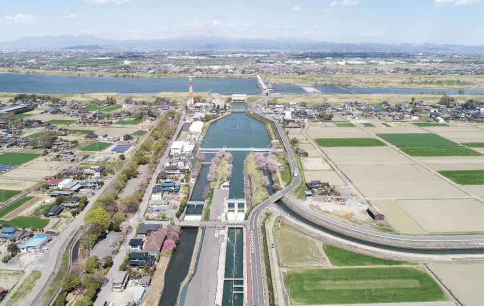
As mentioned above, the Minuma-Dai Irrigation System was constructed based on not only innovative vision and construction technology but also innovative planning of its facility arrangement. The location of “Motoiri” (intake gate) at the Tone River was selected in consideration of the direction and force of water flow, and so on. When the Tone Barrage was constructed in 1968 with modern civil engineering, its selected location was where the original Motoiri was built, proving that the engineering standard at that time was quite high. When making the route plan of the Minuma-Dai Canal, Izawa designed it in a way to partly utilize the existing river as the canal to shorten the work period to a large extent, as well as utilize inflow water of the existing river as additional water sources.
The structure was an example of engineering marvel or excellence at the time of its construction;
The intake and river-crossing on the way were some of the largest wooden structures in Japan of that time built with an outstanding level of technical skills. The intake gate of the Minuma Motoiri (3.6 m wide, and 1.5 m high) had a box culvert structure with wooden framed packs of stones placed to prevent sediment influx and scours. The box culvert structure employed some improved safety features of suppressing buoyancy under their weight on the upper side. At the point where the canal needed to cross the Moto-Ara River, the inverted syphon of the Shibayama Fusekoshi (47 m long) was constructed. On top of the Fusekoshi, the earthen bridge was made to prevent the siphon from surfacing. Such an inverted siphon structure is still adopted now.
The structure contributed to the evolution of efficient and contemporary engineering theories and practices;
The characteristics of Kishu-Ryu were the separation of irrigation and drainage canals and fixing of the river and canal route with the strong embankment and revetment. A drastic change of engineering method from Kanto-Ryu, which fully utilized the natural topography, to Kishu-Ryu contributed to the stable water supply, drainage improvement in farmland, and flood damage reduction. The combination of those separate water supply/drainage and fixed channel route methods was the pioneering technology in water utilization and flood control of today. For accurate level surveying, “Mizumoriki” was used. Its accuracy was proven with a margin of error of just 6 cm for the total length of some 80 km, which was almost equal to the present measurement accuracy.
The structure is an example of attention to environmental aspects in its design and construction;
The excavation work of the Minuma-Dai Irrigation System was conducted with minimum alteration of the natural environment, maximizing the use of the existing river in the area for the canal. The canal constructed along the contour line with the woods on slope constituted a beautiful landscape of the rural area. Even at present under the encroaching urbanization, part of such a peaceful landscape is still preserved. Furthermore, drainage water after stable irrigation through the Minuma-Dai Irrigation System is returned to the downstream rivers, thus an extensive water recycling system is organized.
The structure was unique in some positive and constructive way;
The construction work took only six months as the government-controlled work thanks to well-organized planning. The project covered 115 diversion works and water gates; 130 bridges; 84.5 km long channelling length, and the total amount of excavated soil accumulated to 1,440,000 m3. The total number of workers reached 900,000. To proceed with the big project within such a short period, the government asked for participation from the villages along the designed canal, then adopted a murauke (village contracting) system of a labour work payment method by the village for compensation for the construction labour. A certain work section was divided by the village and all the works were performed virtually all together. Additionally, as to the wooden facilities made of combined wooden sluice pipes and gate materials, carpenters in Edo processed them based on the drawings and processed materials were carried to the construction sites and installed.
The structure bears the stamp of a cultural tradition or a civilization of past;
At key spots of work along with the Minuma-Dai Irrigation System, small shrines were installed with Benzaiten (Japanese Goddess of water) statues to pray for safe construction work. Such a Benzaiten statue in a shrine was placed on the three spots along the canal. Even nowadays a festive event is held, praying for a stable water supply as well as a rich harvest every year. Tsusenbori was recognized as a designated national historical site in 1982 as the oldest wooden lock canal in Japan, being honoured for its historical and cultural value. At the end of August every year, a lock opening and closing demonstration are carried out with restored facilities.
Engineering utility vis-à-vis designed utility
When the canal was originally built, it was mostly an earth canal. “Fusekoshi” (inverted siphon), “Kakedoi” (aqueduct bridge), diversion work and water gates were made of wood. So, they have been repaired and maintained numerous times, but they were finally remodelled into a concrete canal (except for the preserved section of the original canal) to ease the maintenance work and provide adequate water supply. The original “Motoiri” (intake gate) was integrated with other water intakes of irrigation and domestic water into Tone Barrage was completed in 1968. As a result, water intake stabilization has been achieved. Also, as a result of rationalization of irrigation water use and modernization of the related facilities from 1963 to 1995, it became possible to convert part of the irrigation water to urban water. This water use diversification now contributes to the increasing water demand in the Tokyo metropolitan area.
The benefitted area has decreased from approximately 15,000 ha to 11,340 ha now, but about 37 m3/s of water is still taken from the Tone River at present and supply to paddy fields located in the farming area extends from the Saitama plain to suburban Tokyo.
Present State of Conservation
The Minuma-Dai Irrigation System has been playing an important role of a water lifeline, supplying urban water in addition to irrigation water which supports local agriculture. The major main canal is properly managed by the Japan Water Agency (JWA) and other main canals and lateral canals are now managed by the Minuma-Dai Yosui Land Improvement District. A part of the eastern route of the canal for 1.1 km still retains the original environment of the days of its construction, including earth canal structure. This zone is owned and managed by the prefectural government as the preserved section of the original canal, along with the bordering forest on a slope to stay away from urbanization development.
Progressive urbanization has brought about many emerging issues such as illegal garbage dumping and an influx of domestic wastewater in addition to the flooding caused by the influx of excessive water from around the canal caused by the recent abnormal weather and torrential rain. Much more close cooperation among canal operators and local municipalities is now becoming essential. Under these circumstances, Land Improvement Districts set up the “Minuma-Dai Yosui Cooperative Council” with related municipalities as its members in 1979 and are doing their best for the proper maintenance and conservation of the canal including its clean-up with mutual assistance among them.
A relaxing waterfront was made for residents and holidaymakers with 57 km long walking trails and over 40 km of the canal lined with cherry blossoms, thanks to the local municipalities and voluntary groups. Thus, the irrigation system is performing multiple functions of water supply and recreation in the suburbs of Metropolitan Tokyo. Also, they hold various events such as walking events and firefly larva releasing events to raise awareness of residents on the roles of the Minuma-Dai Irrigation System.
For school education, supplementary textbooks on social studies and educational materials of local municipalities used at elementary schools in Saitama Prefecture introduce the Minuma-Dai Irrigation System and achievement of great works of Izawa for enlightenment toward future generations. The Minuma-Dai Yosui Land Improvement District erected the bronze statue of Izawa, originator of the canal in 2005 in Minuma Nature Park to honour him for this feat and showcase the importance of the irrigation system as a local resource.
HIGHLIGHTS
Country: Japan
Province: Saitama Prefecture
Latitude : 38.18535107 Longitude : 139.4713068
Built: 1728
River: Tone River
Basin: Tone River basin
Irrigated Area: 11340 Ha
70th IEC Meeting, Bali, Indonesia, 2019