Menu
Menu
Kikuchi Irrigation System
Profile; ?>Project System and Heritage Composition
The Kikuchi Region is located in the middle area of Kyushu Island, the most western of the four main islands of Japan. The Kikuchi River is 71 km long and the area of the watershed is 996 km2. The “Kikuchi Irrigation Systems” consists of four irrigation systems, which were sequentially constructed in the watershed in 1596–1835: 1) Tsuiji-ide Irrigation System, 2) Haru-ide Irrigation System, 3) Imamura-ide/Houei-zuido Irrigation System, and 4) Furukawahyodo-ide Irrigation System. Note: The word “ide” means an irrigation system and “zuido” is the tunnel in Japanese.
These irrigation systems represent the developmental process of agricultural engineering in the pre-modern period of Japan (since the early 17th century to the 19th century). In particular, outstanding techniques for the excavation of canals and tunnels can be seen in the irrigation systems because these irrigation structures were constructed in mountainous areas. The management rule of irrigation water was also sophisticated by the sequential construction of the irrigation systems because the newer one dealt with bigger restrictions in the usage of river water.
The salient features of each irrigation system are as follows.
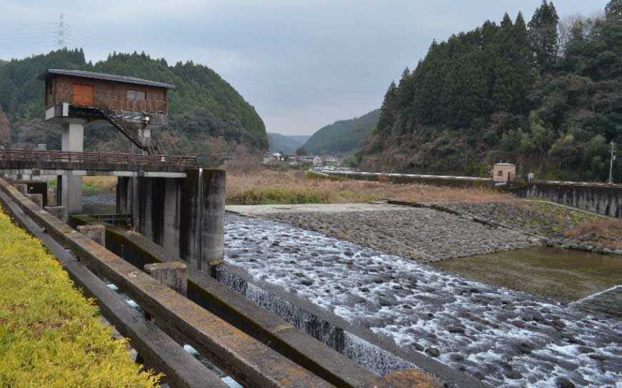
1) Tsuiji-ide Irrigation System (KIS-No.1) was constructed to develop about 230 ha of rice fields in 1596–1615 (about 400 years ago). A wise ruler of the region directed the construction. Although the irrigated area decreased due to urbanization, the irrigation system currently has multi-functional roles. The irrigation canals provide a beautiful townscape and act as a drainage facility for flood water.
2) Haru-ide Irrigation System (KIS-No.2A) was constructed in 1698–1701, about one hundred years after the construction of KIS-No.1. A village leader planned and constructed the irrigation system. This history proves that the local society was democratized during the 100 years since the construction of KIS-No.1. Because the irrigation system was constructed to develop about 70 ha of rice fields after the construction of KIS-No.1, excavation of an approximately 11-km irrigation canal with a 450-m tunnel in the mountainous area was required. Now, the irrigation system is considered not only as an irrigation facility but also as an important regional resource that vitalizes the local community. Canoeing using the irrigation canal is a good example of this.
3) Imamura-ide/Houei-zuido Irrigation System (KIS-No.2B) was constructed for 220 ha of rice fields in 1705. This irrigation system was planned almost at the same time as KIS-No.2A. The main irrigation canal is about 6.5 km and there is a 300 m tunnel (height = 2 m). Currently, the tunnel is also used as an educational tool of history and agricultural engineering.
4) Furukawahyodo-ide Irrigation System (KIS-No.3) was constructed to develop 180 ha of rice fields in 1813–1835, about one hundred years after the construction of KIS-No.2A and No.2B. The excavation of about 2.4-km water channel through a mountain was to be necessary to obtain water from the adjacent watershed because the flow volume of the river was not sufficient for the additional development of rice fields. A 19-km irrigation canal was also excavated in the mountainous area.
Water Heritage
The structure represents a milestone/turning points in the development of irrigated agriculture and bears exceptional testimony to the development of agriculture and an increase in food production along with the improvement of the economic condition of farmers;
The Kikuchi Irrigation Systems (KIS-No.1, No.2A, No.2B and No.3) were sequentially constructed starting in the early 17th century, finishing in the 19th century. The first irrigation system (KIS-No.1) was planned around the end of the age of civil wars in Japan. The irrigation canal of KIS-No.1 was constructed using the techniques which had been sophisticated during the previous age, in the early 17th century. The second and third irrigation systems (KIS-No.2A and No.2B) were constructed in the early 18th century. Long irrigation canals and tunnels were excavated to develop the mountainous area. Additionally, the construction of KIS-No.2A and No.2B was planned not by a ruler of the region but a village leader, reflecting the democratization of the local society in Japan. The last irrigation system (KIS-No.3) was constructed to develop rice fields in the most upstream area of the river watershed in the 19th century. Therefore, it can be said that the location of the irrigation systems represents the development process of the river watershed. The developmental process of agricultural engineering in the pre-modern period of Japan can be seen through the irrigation systems. In particular, excavation techniques of canals and tunnels, which were sophisticated in the construction process of the irrigation systems, were important. Those techniques were widely applied to other irrigation systems in later years.
The structure made outstanding contribution to enhancing food production, livelihood opportunities, rural prosperity, and poverty alleviation in a region;
The Kikuchi Irrigation Systems have provided a great contribution to the development of rice fields in the river watershed. About 700 ha of rice fields was developed by the irrigation systems. Also, the irrigation systems, KIS-No.2A and No.3 supplied not only irrigation water but also drinking water. The irrigation systems did a lot to alleviate poverty in the mountainous area because it was hard for the villagers to obtain water. The irrigation systems have been reinforced and are still supplying irrigation water to about 615 ha of rice fields in the river watershed.
The structure was innovative in its ideas at the time of its construction;
When the villagers planned the construction of the last irrigation system (KIS-No.3), they had to find another water resource because the river water had been used by the previous irrigation systems (KIS-No.1, No.2A, and No.2B). They planned the construction of the water channel that connects the river to the adjacent river through a mountain to abstract additional irrigation water. They had to persuade a ruler to give them official permission to excavate the water channel because there was no precedent at the time. The length of the water channel was about 2.4 km. Also, the main irrigation canal of KIS-No.3 is about 19 km long. It took more than 11 years to construct the irrigation system. In addition, it cost 5.8 million USD (exchange rate: 1 USD = 100 Japanese yen). This cost indicates the difficulties of the construction and the innovative nature of the idea.
The structure was an example of engineering marvel or excellence at the time of its construction;
Sophisticated techniques of excavation of tunnels were necessary to develop the mountainous area. Three irrigation systems (KIS-No.2A, No.2B, and No.3) have long tunnels of more than a hundred meters. Those tunnels are good examples of agricultural engineering at the time. In particular, the construction process at the time can be seen in the tunnel of KIS-No.2B, which was about 300 m long and excavated in a short time (only 100 days). Two vertical holes for ventilation and one lateral hole for flushing sediments have been conserved in the tunnel of KIS-No.2B as they were at the time.
Engineering utility vis-à-vis designed utility
The Kikuchi Irrigation Systems (KIS-No.1, No.2A, No.2B and No.3) still have an important role in rice production and have kept their original functions for several hundred years. The irrigated area of the irrigation systems is 615 ha today. The locations and scales of the irrigation systems are almost the same as when they were built.
However, there are many disasters such as typhoons, heavy rainfall and floods, earthquakes, and volcanic eruptions in Japan. Parts of the irrigation structures have been repaired and reinforced by concrete or steel after some of these disasters.
Droughts can also cause serious water conflicts in the river watershed. All inlets of the irrigation systems were repaired to intake water efficiently. Also, the irrigation canals were partially paved by concrete to prevent water loss. The water channel of KIS-No.3 has not been used since a large concrete dam was constructed in the river watershed.
Present State of Conservation
The Kikuchi Irrigation Systems (KIS-No.1, No.2A, No.2B and No.3) have been maintained and used by the local communities for a long time although the irrigation structures were destroyed many times by disasters such as floods and earthquakes. For example, the wall in the tunnel of KIS-No.2B was partially destroyed by the “Kumamoto Earthquake” (Mw7.0) in 2016. However, the irrigation canal (tunnel) of KIS-No.2B was repaired because of human power. Many irrigation structures, especially irrigation tunnels, have been conserved in the irrigation systems as they were when they were built although the inlets (weirs) of the irrigation systems are replaced by steel weirs and the irrigation canals are partially paved by concrete.
The irrigation structures and cultivated lands in the Kikuchi River watershed have been selected as “Japan Heritage” because they can be considered a miniature model of the historic record and culture of Japanese rice farming. Kikuchi Irrigation Systems is one of the most important components of heritage.
Currently, the Kikuchi Irrigation Systems are mainly managed by a single organization (Kikuchi Land Improvement District). Professional staff members are employed by the organization. Water conflicts among the irrigation systems due to droughts, which occurred frequently in old times, are mitigated by the organization.
The irrigation structures are used not only for irrigation but also for the revitalization of the local community. For example, the old tunnel of KIS-No.2B is used as an educational tool for primary school children. Canoeing in the irrigation canal of KIS-No.3 is also a good example of the multiuse nature of the irrigation system. This activity was selected as a recipient of the “Sport and Culture Tourism Award 2018” by the Agency for Cultural Affairs of the Japanese government.
HIGHLIGHTS
Country: Japan
Province: Kumamoto Prefecture
Latitude : 32.98828276 Longitude : -229.17170137
Built: 1615
River: Kikuchi River Basin
Irrigated Area: 615 ha; 85 ha (Tsuiji-ide Irrigation System), 210 ha (Haru-ide Irrigation System), 190 ha (Imamura-ide/Houei-zuido Irrigation System), and 130 ha (Furukawahyodo-ide Irrigation System)
70th IEC Meeting, Bali, Indonesia, 2019