Menu
Menu
Hindiya Barrage
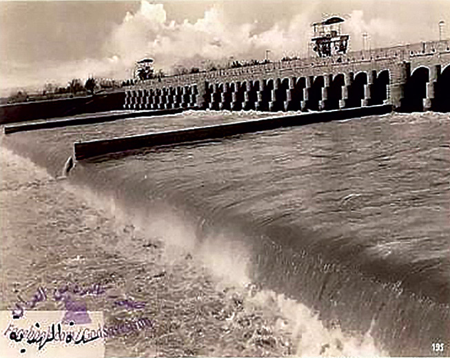
Profile; ?>The heritage dam was established on the Euphrates River, south of Baghdad, at the place where the Euphrates River divides into the Hindiya and Hilla branches, to replace an old (weir) dam called the Shundervarkan Dam, which was established there before the construction of the barrage and the latter began working in 1911 and finished in 1913. The barrage was named Hindiya after Al-Hindiya River south of the dam, whose name went back to Yahya Asif al-Dawla, Bahadur al-Hindi, who was a minister with the King of India (Muhammad Shah al-Hindi) who opened and implemented a stream that took water from the right bank of the Euphrates River to deliver water to the city of Najaf, whose people were suffering from drought and this stream was later on known as Al-Hindiyah River in relation to the Indian Asif al Dawla. The purpose of establishing the barrage was to raise the water level in the head of the dam to secure water to the Hilla branch.
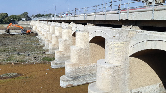
The Hindiya barrage, made of bricks, is similar to the oldest regulators in Egypt in its construction method. The original design of the Hindiya barrage was done by Sir Willem Wilcox. He set the design of the Hindiya barrage in two parts: the first is the main barrage and the second part is the barrage itself plus a submersible dam at its rear.
The specifications of the Hindiya barrage and its submersible dam are given below:
- The width of the barrage: 237.5 m between the retaining wall on the right abutment and the exterior wall of the ship lanes (Lock) on the left side.
- The number of openings equals 36 arches divided into three basins, each of which contains twelve openings (5 m wide each).
- The number of abutments is equal to 33, each of which is 1.5 m wide, and two main abutment piers each of 3.5 m wide, which are the twelfth and twenty-fourth.
- The width of the barrage is equal to 3.85 m between the curtains.
- The ship lane (left bank) is equal to 8 m in width and 131 m in length, and a drawbridge has been erected above it, and there are three pairs of iron gates.
- Floor Level (front and back) = 26.35 m
- Level of the submerged dam’s top in the south of the barrage = 27.35 m
- Ground-level in the South of the Submerged Dam = 24.85 m
- Level of the beginning of the Arch = 32.35 m; Crown of the Arch = 33.35 m
- Highest flood level: Head of the dam = 32.60 m; Back of the dam = 32.35 m; Back of the submerged dam = 32.1 m
- Water Level in Summer: Top of the dam = 31.35 m; Back of the dam = 27.85 m; Back of the submerged dam = 26.35 m
- Hydraulic Gradient of the Barrage = 1: 10.4
- Gate Type = Each gate has two movable shutters
Solving the Irrigation Problem: The proposal to build the Hindiya Barrage in its ancient site was a lifeline, as the water was cut off from Shatt al Hilla in the dry season. Presently it irrigates an area of nearly 550,000 ha.
Barrage as a Water Regulator: The barrage was used to regulate the water and distribute it alternately on the streams located in the north of the barrage on one side and the river course located in the south of the dam on the other side, and this shift system differs according to the seasons of the year and the need for winter’s and summer’s crops, and below is a table of levels, discharges and areas of Hindiya Barrage.
HIGHLIGHTS
Country: Iraq
Province: Baghdad
Latitude : N 32 ° 42 ′ 46 '' Longitude : E 44 ° 16 ′ 02 ''
Built: 1913
River: Euphrates River / Shatt Al-Hindiya / Shatt Al-Hill
Irrigated Area: 550,000 ha
72nd IEC Meeting, Marrakesh, Morocco, 2021